
 الرئيسية
 الأحداث
 المنشورات
 أحدث الصور
 التسجيل
 دخول
دخولإلى هواة الطوابع؛ الاحتلال الأسباني يعترف بفضل الإدريسي الأندلسي في الجغرافيا
منظمة الشعب الأندلسي العالمية World Organization of Andalusian People :: علوم الأندلسيين القدامى-ANCIENT ANDALUSIANS’ SCIENCES - CIENCIA ANDALUZA – SCIENCES DES ANCIENS ANDALOUS :: العلوم الإنسانية
صفحة 1 من اصل 1

إلى هواة الطوابع؛ الاحتلال الأسباني يعترف بفضل الإدريسي الأندلسي في الجغرافيا
من طرف أ. د. جمال بن عمار الأحمر الثلاثاء 26 نوفمبر 2013, 19:43
إلى هواة الطوابع؛
الاحتلال الأسباني يعترف بفضل الإدريسي الأندلسي في الجغرافيا

الإدريسي
من ويكيبيديا، الموسوعة الحرة
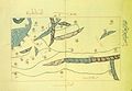
 صورة تخيلية للإدريسي. | |
| 1099 م سبتة | |
| 1160 م صقلية | |
| مرابطي | |
| جغرافي كاتب عالم راسم الخرائط | |
| نزهة المشتاق في اختراق الآفاق | |

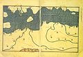
خريطة الوطن العربي، التي رسمها الإدريسي لروجر الثاني ملك صقلية عام1154 م، واحدة من خرائط العالم القديمالأكثر تقدما. صورة منسقة حديثة ، تم إنشاؤها من 70 صفحة مفرودة من الأطلس الأصلي"(لاحظ أن الشمال هو في الأسفل، وهكذا يظهر على الخريطة "رأسًا على عقب")".
أبو عبد الله محمد بن محمد الإدريسي الهاشمي القرشي. عالم مسلم وأحد كبار الجغرافيين فيالتاريخ ومؤسسي علم الجغرافيا ، كما أنه كتب في التاريخ والأدب والشعر والنبات ودرس الفلسفةوالطب والنجوم في قرطبة. استخدمت مصوراته وخرائطه في سائر كشوف عصر النهضة الأوربية. حيث لجأ إلى تحديد اتجاهات الأنهار والبحيرات والمرتفعات ، وضمنها أيضًا معلومات عن المدن الرئيسية بالإضافة إلى حدود الدول.
[/rtl][/font]
نشأته[عدل]
[/rtl][/font]

خريطة للإدريسي التي رسمها للملك روجر الثاني، ويلاحظ أن الخريطة مقلوبة لأن الناس في تلك الأيام كانوا يعتبرون أن الجنوب يوجد في الأعلى.
اسمه الكامل (كما جاء في الوافي بالوفيات) هو: محمد بن محمد بن عبد الله (لا عبد الرحمن) بن إدريس بن يحيى بن علي بن حمود (صاحب غرناطة في وقته) بن ميمون بن أحمد بن علي بن عبيد الله بن عمر بن إدريس بن إدريس بن عبد الله بن الحسن المثنى بن الحسن بن علي بن أبي طالب بنعبد المطلب بن هاشم القرشي.
ولقب بالصقلي لأنه اتخذ جزيرة صقلية مكاناً له بعد سقوط الدولة الإسلامية. ولقب بسطرابون العرب نسبة للجغرافيالإغريقي الكبير سطرابون. وقد كان من أبرز الدارسين في علم الرياضيات فقد اخترع علم الهندسة قديمًا قبلارخميدس.
ولد في مدينة سبتة في المغرب الأقصى عام 493 هـ (1100 م) ومات عام 559هـ 1166م. تعلم في البيلق وطاف البلاد فزار الحجاز و تهامة ومصر. وصل سواحل فرنسا وإنكلترا. سافر إلى القسطنطينية وسواحل آسيا الصغرى. عاش فترة في صقلية ونزل فيها ضيفًا على ملكها روجر الثاني، ولا نعرف شيء عن نهاية حياته ومكان وفاته.
اختار الإدريسي الانتقال إلى صقلية بعد سقوط الدولة الإسلامية ، لأن الملك النورماني في ذلك الوقت "روجر الثاني" كان محبًا للمعرفة. شرح الإدريسي لروجر موقع الأرض في الفضاء مستخدمًا في ذلك البيضة لتمثيل الأرض، شبه الإدريسي الأرض بصفار البيضة المحاط ببياضها تماما كما تهيم الأرض في السماء محاطة بالمجرَّات.
أمر الملك الصقلي روجر الثاني له بالمال لينقش عمله خارطة العالم والمعروف باسم "لوح الترسيم" على دائرة من الفضة. في إحدى المرات قدم وصفًا عن وضع السودان، وعن حالة مدن مثل " المواقع بدقة متناهية تمامًا، كما هي على أرض الواقع، مع أنها كانت فقط من خلال الاستماع إلى بعض القصص والكلمات. استخدم الإدريسيخطوط العرض أو الخطوط الأفقية على الخريطة والكرة الأرضية التي صنعها، استخدمت خطوط الطول من قبله إلا أن الإدريسي أعاد تدقيقها لشرح اختلاف الفصول بين الدول. دُمرت تلك الكرة خلال اضطرابات مدنية فيصقلية بعد وفاة الملك "روجر الثاني" .في جزيرة صقلية تفتقت مواهبه العلمية وقام بعمله الخالد الذي عرف به فيالتاريخ، وكانت صقلية في ذلك العهد قد خرجت من حكم المسلمين، وخضعت لحكم النورمان المسيحيين، وإن كانالمسلمون يكونون فيها أكبر جالية من السكان غير المسيحيين، وكان ملوكها من النورمان وخاصة روجر الثانيالذي عاش الشريف في أكنافه، يتشبه بالمسلمين ويتظاهر بعاداتهم في اللباس والهيئة وشارات الملك، ويخالف عادةالإفرنج في كل ذلك .. وكان يكرم المسلمين ويقربهم وينتفع بخبرتهم ومعارفهم .. قال صلاح الدين الصفدي في ترجمة الشريف الإدريسي من كتابه "الوافي بالوفيات" عن الملك روجر الثاني : «"وهو الذي استقدم الشريف الإدريسي صاحب كتاب "نزهة المشتاق في اختراق الآفاق" ليصنع له شيئا في شكل صورة العالم..".»
حدد الإدريسي مصدر نهر النيل، ففي موقع معين وضع نقطة تقاطع نهر النيل تحت خط الإستواء، وهذا هو موقعه الصحيح. قبل دخول مصر تلتقي روافد نهر النيل في الخرطوم عاصمة السودان، يتشكَّل نهر النيل من نهرين هما النيل الأبيض والنيل الأزرق ، يجري هذان النهران عبر أراضي السودان ويلتقيان في الخرطوم التي تقع تحت خط الإستواء . إن تحديد موقع نهر النيل يُلغي نظرية بطليموس أن مصدر نهر النيل هو تلة فيالقمر.
[/rtl][/font]

اشتهر الشريف الإدريسي بولعه بالبحار وحركتها، وقد كان ميناء سبتة في عهده يعرف حركة تجارية كبيرة، وقد كانت تجذب صاحبنا السفن التجارية الراسية في ميناء سبتة، وكان يعتمل في داخله شوق كبير لاستكشاف الدُّول التي كانت تُبحر منها وإليها هذه السفن، وسرعان ما تحوَّلت رغبته إلى حقيقة عندما رحل لمتابعة تحصيله العلمي في قرطبة، فترسخ لديه ميوله إلى العلوم الطبيعية خصوصا علمي الجغرافيا والنبات.
[/rtl][/font]
.jpg)
ويعتبر الشريف الإدريسي أحد كبار الجغرافيين في التاريخ الإنساني، كما كان له اهتمام بالتاريخ، والأدب، وعلم النبات، والطب،والفلك.. أخذ العلم بسبتة وقرطبة، وزار الحجاز و تهامة ومصر، ووصل سواحل فرنسا وإنجلترا، وسافر إلى القسطنطينية وآسيا الصغرى. ثم عاش فترة في صقلية ونزل فيها ضيفًا على ملكها روجر الثاني، وقد عانى مدة طويلة من الغربة عن بلده سبتة. نستشف ذلك من شعر من نظمه يقول فيه:
[/rtl][/font]
| ليـت شعــري أيـن قبـري | ضــاع في الغربة عمـري |
| لم أدع للعين ما تشتـــاق | فـــي بـــر وبـــحـر |
مؤلفاته[عدل]
ألف الإدريسي كتابه المشهور (نزهة المشتاق في اختراق الآفاق) والمسمى أيضًا (كتاب روجر) أو (الكتاب الروجري) وذلك لأن الملكروجر ملك صقلية هو الذي طلب منه تأليفه كما طلب منه صنع كرة من الفضة منقوش عليها صورة الأقاليم السبعة، ويقال أن الدائرة الفضية تحطمت في ثورة كانت في صقلية، بعد الفراغ منها بمدة قصيرة، وأما الكتاب فقد غدا من أشهر الآثار الجغرافية العربية، أفاد منهالأوروبيون معلومات جمة عن بلاد المشرق، كما أفاد منه الشرقيون، فأخذ عنه الفريقان ونقلوا خرائطه، وترجموا بعض أقسامه إلى مختلف لغاتهم ويعد هذا الكتاب فريد من نوعه استغرق تأليفه 15 عامًا حيث نهج فيه الإدريسي نهجاً جديداً عن غيره من الجغرافيينالمسلمين فقد وصف العالم ككل ثم قسمه إلى سبعة أقاليم وكل إقليم إلى عشرة اقسام رئيسيه ثم وصف كل قسم ورسم له خريطة وتحاشى فيه الخلط بين التاريخ والجغرافيا وظل كتابه مرجعًا لعلماء أوروبا أكثر من ثلاثة قرون.
[/rtl][/font]


سان بطرسبرج تظهر في خريطة لـ الإدريسي ، ويبين : جزء من ساحل البحر الأسود من خليج نهر الدانوب ومنطقة دوبروجا ، في الشرق هم جزء من روسيا الأوروبية ، ومنطقة نهري دنيستر ودنيبر.

سان بطرسبرج تظهر في خريطة لـ الإدريسي ، ويظهر بحر الشمال مرمرة ،شبه جزيرة غاليبولي ، بحر إيجة ، دلتا نهر ماريتسا ، منطقة مقدونيا ، أجزاء من وسط اليونان.
و في كتاب (نزهة المشتاق في اختراق الآفاق) اشتهر الإدريسي بأنه هو الذي طور رسم الخرائط بطريقة أكثر دقة منالخرائط التي كانت معروفة من قبل .يمكن رؤية ذلك بوضوح في خرائطه، حيث لجأ إلى تحديد اتجاهات الأنهاروالبحيرات والمرتفعات ، وضمنها أيضًا معلومات عن المدن الرئيسية بالإضافة إلى حدود الدول .. وقد استخدم الإدريسي خطوط العرض أو الخطوط الأفقية على الخريطة والكرة الأرضية التي صنعها، وكانت خطوط الطول قد استخدمت قبل الإسلام، إلا أن الإدريسي أعاد تدقيقها لشرح اختلاف الفصول بين الدول. وإن خط العرض الذي رُسم اعتباطيا على الخريطة، كان يستخدم عادة لتحديد الفصول وحالة الطقس شمال وجنوب خط الإستواء، لذا فإن مثل هذا التقسيم يوضح فهم الإدريسي للبلدان المختلفة، وهذا ما يشهد على تفوقه وعلو همته . ومن أعظم مؤلفاته في السنة التي وضع فيها الإدريسي كتابه المعروف ، توفي الملك روجر فخلفه غليام أو غليوم الأول، وظل الإدريسي على مركزه في البلاط، فألف للملك كتابًا آخر في الجغرافيا سمّاه (روض الأنس ونزهة النفس) أو (كتاب الممالك والمسالك)، لم يعرف منه إلا مختصر مخطوط موجود في مكتبة حكيم أوغلو علي باشا بإسطنبول . وذكر للإدريسي كذلك كتاب في المفردات سماه (الجامع لصفات أشتات النبات)، كما ذكر له كتاب آخر بعنوان (أُنس المُهَج وروض الفرج). وقد نشر من هذا الكتاب الأخير "قسم شمال أفريقيا وبلاد السودان". [1].
وفاته[عدل]
توفي الشريف الإدريسي في عام 560 هـ (1166م).[/rtl][/font]
http://ar.wikipedia.org/wiki/%D8%A7%D9%84%D8%A5%D8%AF%D8%B1%D9%8A%D8%B3%D9%8A
http://fr.wikipedia.org/wiki/Al_Idrissi

أ. د. جمال بن عمار الأحمر- رئيس منظمة الشعب الأندلسي العالمية

- الجنس :

العمر : 64
تاريخ الميلاد : 22/02/1960
تاريخ التسجيل : 02/05/2009
عدد المساهمات : 2938
نقاط الشكر على الجدية الأندلسية : 3
نشاطه في منظمة ش الأندلسي ع : 4879
العمل/الترفيه : أستاذ جامعي. مؤسس في حركة إسلامية قوية في نهاية السبعينيات. وسياسي قديم. ومرشح برلماني سابق -

رد: إلى هواة الطوابع؛ الاحتلال الأسباني يعترف بفضل الإدريسي الأندلسي في الجغرافيا
من طرف أ. د. جمال بن عمار الأحمر الثلاثاء 26 نوفمبر 2013, 19:46
[ltr]
"Edrisi" redirects here. For places in Iran, see Edrisi, Iran.
[/ltr]
.jpg) Statue of Al-Idrisi in Ceuta | |
| 1099 Ceuta, Morocco (present-day Spain) | |
| 1161 Sicily | |
| Geographer Writer ScientistCartographer | |
| Tabula Rogeriana | |
Abu Abd Allah Muhammad al-Idrisi al-Qurtubi al-Hasani al-Sabti or simply Al Idrisi (Arabic: أبو عبد الله محمد الإدريسي القرطبي الحسني السبتي; Latin: Dreses) (1099–1165 or 1166) was an Arab Muslim geographer, cartographer, Egyptologist and traveller who lived in Sicily, at the court of King Roger II. Muhammed al-Idrisi was born in Ceuta, then belonging to the Moroccan Almoravids, and died in Sicily. Al Idrisi was a descendant of the Idrisids, who in turn were descendants of Hasan bin Ali, the son of Ali and the grandson of the Islamic prophet Muhammad.[1]
[/ltr][/font]
- 1 Early life
- 2 Tabula Rogeriana
- 2.1 Description of islands in the North Sea
- 2.2 Description of Chinese trade
Early life[edit]
Al-Idrisi was born into the large Hammudid family of North Africa and Al-Andalus, which claimed descent from the Idrisids of Morocco and ultimately the prophet Muhammad.[2]
Al-Idrisi was born in the city of Ceuta, where his great-grandfather had been forced to settle after the fall of Hammudid Malaga to the Zirids of Granada.[3] He spent much of his early life travelling through North Africa and Al-Andalus and seems to have acquired detailed information on both regions. He visited Anatolia when he was barely 16. He is known to have studied in Córdoba
Apparently his travels took him to many parts of Europe including Portugal, the Pyrenees, the French Atlantic coast, Hungary, andJórvík also known as York, in England.
Tabula Rogeriana[edit]
Main article: Tabula Rogeriana
[/ltr][/font]

The Tabula Rogeriana, drawn by al-Idrisi for Roger II of Sicily in 1154, one of the most advanced ancient world maps. Modern consolidation, created from the 70 double-page spreads of the original atlas.
(Note that the north is at the bottom, and so the map appears "upside down")
Al-Idrisi was born and raised in Ceuta. At an early age he traveled to Islamic Spain, Portugal, France and England, and visited Anatolia when he was barely 16. Because of conflict and instability in Al-Andalus al-Idrisi joined contemporaries such as Abu al-Salt in Sicily, where the Normans had overthrown Arabs formerly loyal to the Fatimids.
Al-Idrisi incorporated the knowledge of Africa, the Indian Ocean and the Far East gathered by Islamic merchants and explorers and recorded on Islamic maps with the information brought by the Norman voyagers to create the most accurate map of the world in pre-modern times,[4] which served as a concrete illustration of his Kitab nuzhat al-mushtaq, (Latin: Opus Geographicum), which may be translated A Diversion for the Man Longing to Travel to Far-Off Places.[5]
The Tabula Rogeriana was drawn by Al-Idrisi in 1154 for the Norman KingRoger II of Sicily, after a stay of eighteen years at his court, where he worked on the commentaries and illustrations of the map. The map, with legends written in Arabic, while showing the Eurasian continent in its entirety, only shows the northern part of the African continent and lacks details of the Horn of Africa and Southeast Asia.
For Roger it was inscribed on a massive disc of solid silver, two metres in diameter.
On the geographical work of al-Idrisi, S.P. Scott wrote in 1904:
[/ltr][/font]
[font][ltr]The compilation of Edrisi marks an era in the history of science. Not only is its historical information most interesting and valuable, but its descriptions of many parts of the earth are still authoritative. For three centuries geographers copied his maps without alteration. The relative position of the lakes which form the Nile, as delineated in his work, does not differ greatly from that established by Baker and Stanley more than seven hundred years afterwards, and their number is the same. The mechanical genius of the author was not inferior to his erudition. The celestial and terrestrial planisphere of silver which he constructed for his royal patron was nearly six feet in diameter, and weighed four hundred and fifty pounds; upon the one side the zodiac and the constellations, upon the other-divided for convenience into segments-the bodies of land and water, with the respective situations of the various countries, were engraved.[4]
Al-Idrisi inspired Islamic geographers such as Ibn Battuta, Ibn Khaldun and Piri Reis. His map also inspired Christopher Columbus andVasco Da Gama.
Description of islands in the North Sea[edit]
Al-Idrisi in his famous Tabula Rogeriana mentioned Irlandah-al-Kabirah (Great Ireland).[6] According to him, "from the extremity ofIceland to that of Great Ireland," the sailing time was "one day." Although historians note that both al-Idrisi and theNorse[disambiguation needed] tend to understate distances, the only location this reference is thought to have possibly pointed to, must likely have been in Greenland.[7]
Description of Chinese trade[edit]
Al-Idrisi mentioned that Chinese Junks carried leather, swords, Iron and Silk. He mentions the glassware of the city of Hangzhou and labels Quanzhou's silk as the best.[8]
Nuzhatul Mushtaq[edit]
[/ltr][/font]

Al-Idrisi's world map.
As well as the maps, al-Idrisi produced a compendium of geographical information with the title Kitab nuzhat al-mushtaq fi'khtiraq al-'afaq. The title has been translated as The book of pleasant journeys into faraway lands[9] or The pleasure of him who longs to cross the horizons.[10]
Publication and translation[edit]
An abridged version of the Arabic text was published in Rome in 1592 with title: De geographia universali or Kitāb Nuzhat al-mushtāq fī dhikr al-amṣār wa-al-aqṭār wa-al-buldān wa-al-juzur wa-al-madā’ in wa-al-āfāq which in English would be Recreation of the desirer in the account of cities, regions, countries, islands, towns, and distant lands.[11][12] This was one of the first Arabic books ever printed.[10] The first translation from the original Arabic was into Latin. The Maronites Gabriel Sionita and Joannes Hesronita translated an abridged version of the text which was published in Paris in 1619 with the rather misleading title ofGeographia nubiensis.[13] Not until the middle of the 19th century was a complete translation of the Arabic text published. This was a translation into French by Pierre Amédée Jaubert.[14] More recently sections of the text have been translated for particular regions. In the 1970s a critical edition of the complete Arabic text was published.[15]
Andalusian-American contact[edit]
Al-Idrisi's geographical text, Nuzhatul Mushtaq, is often cited by proponents of pre-Columbian Andalusian-Americas contact theories. In this text, al-Idrisi wrote the following on the Atlantic Ocean:
[/ltr][/font]
[font][ltr]The Commander of the Muslims Ali ibn Yusuf ibn Tashfin sent his admiral Ahmad ibn Umar, better known under the name of Raqsh al-Auzz to attack a certain island in the Atlantic, but he died before doing that. [...] Beyond this ocean of fogs it is not known what exists there. Nobody has the sure knowledge of it, because it is very difficult to traverse it. Its atmosphere is foggy, its waves are very strong, its dangers are perilous, its beasts are terrible, and its winds are full of tempests. There are many islands, some of which are inhabited, others are submerged. No navigator traverses them but bypasses them remaining near their coast. [...] And it was from the town of Lisbon that the adventurers set out known under the name of Mughamarin [Adventurers], penetrated the ocean of fogs and wanted to know what it contained and where it ended. [...] After sailing for twelve more days they perceived an island that seemed to be inhabited, and there were cultivated fields. They sailed that way to see what it contained. But soon barques encircled them and made them prisoners, and transported them to a miserable hamlet situated on the coast. There they landed. The navigators saw there people with red skin; there was not much hair on their body, the hair of their head was straight, and they were of high stature. Their women were of an extraordinary beauty.[16]
This translation by Professor Muhammad Hamidullah is however questionable, since it reports, after having reached an area of "sticky and stinking waters", the Mugharrarin (also translated as "the adventurers") moved back and first reached an uninhabited island where they found "a huge quantity of sheep the meat of which was bitter and uneatable" and, then, "continued southward" and reached the above reported island where they were soon surrounded by barques and brought to "a village whose inhabitants were often fair-haired with long and flaxen hair and the women of a rare beauty". Among the villagers, one spoke Arabic and asked them where they came from. Then the king of the village ordered them to bring them back to the continent where they were surprised to be welcomed by Berbers.[17][verification needed]
Apart from the marvellous and fanciful reports of this history, the most probable interpretation[citation needed] is that the Mugharrarinreached the Sargasso Sea, a part of the ocean covered by seaweed) which is very close to Bermuda yet one thousand miles away from the American mainland. Then while coming back, they may have landed either on the Azores, or on Madeira or even on the westernmost Canary Island, El Hierro (because of the sheep). Last, the story with the inhabited island might have occurred either onTenerife or on Gran Canaria, where the Mugharrarin presumably met some Guanche tribe. This would explain why some of them could speak Arabic (some sporadic contacts had been maintained between the Canary Islands and Morocco) and why they were quickly deported to Morocco where they were welcomed by Berbers. Yet, the story reported by Idrisi is an indisputable account of a certain knowledge of the Atlantic Ocean by the Arabs and by their Andalusian and Moroccan vassals.
In popular culture[edit]
[/ltr][/font]
- Al Idrisi is the main character in Tariq Ali's book entitled A Sultan in Palermo.
- Al Idrisi is the title character in Jon Fasman's book entitled The Geographer's Library.
- Al-Idrisi's works had a profound influence on European writers such as: Marino Sanuto the Elder, Antonio Malfante, Jaume Ferrerand Alonso Fernández de Lugo.
- The popular IDRISI GIS system, developed by Clark University, is named after Muhammad al-Idrisi
Gallery[edit]
[/ltr][/font]
Al-Idrisi's map of theIndian Ocean.
Al-Idrisi's map of what is modern day Azerbaijanand the Caspian Sea.
Al-Idrisi's map of the northern shoreline ofMarmara Region.
Al-Idrisi's map of theBalkans.
Al-Idrisi's map of theBalkans.
Al-Idrisi's map of theIberian peninsula.
Al-Idrisi's map of theIberian peninsula.
Al-Idrisi's description ofFinland
Map of the Senegal Riveraccording to Al-Idrisi.- http://en.wikipedia.org/wiki/Muhammad_al-Idrisi


أ. د. جمال بن عمار الأحمر- رئيس منظمة الشعب الأندلسي العالمية
- الجنس :
العمر : 64
تاريخ الميلاد : 22/02/1960
تاريخ التسجيل : 02/05/2009
عدد المساهمات : 2938
نقاط الشكر على الجدية الأندلسية : 3
نشاطه في منظمة ش الأندلسي ع : 4879
العمل/الترفيه : أستاذ جامعي. مؤسس في حركة إسلامية قوية في نهاية السبعينيات. وسياسي قديم. ومرشح برلماني سابق -
» مسجد قصر الحمراء بغرناطة الأندلس، بعدما حوله الاحتلال الأسباني إلى كنيسة
» برامج جمع الطوابع StampManage
» جهود الأسباني (خليل بن أمية) (Rodolfo Gil BENUMEYA)
» برامج جمع الطوابع StampManage
» جهود الأسباني (خليل بن أمية) (Rodolfo Gil BENUMEYA)
منظمة الشعب الأندلسي العالمية World Organization of Andalusian People :: علوم الأندلسيين القدامى-ANCIENT ANDALUSIANS’ SCIENCES - CIENCIA ANDALUZA – SCIENCES DES ANCIENS ANDALOUS :: العلوم الإنسانية
صفحة 1 من اصل 1
صلاحيات هذا المنتدى:
لاتستطيع الرد على المواضيع في هذا المنتدى


» حمل المئات من كتب النحو والصرف والإعراب (أمهات الكتب)
» ألقاب عائلات أندلسية في الجزائر
» Ansys Electromagnetics Suite 2024 R1
» لقب: خلـــيفة، بالشرق الجزائري
» مسرحية (ولادة)، علي عبد العظيم (نالت الجائزة الأولى للتأليف المسرحي من وزارة الشؤون الاجتماعية، بمصر)، 1948م
» WSDOT BridgeLink v7.0.1.0 English 64-bit
» UniSoft GS UniSettle v4.0.0.58 English 32-64-bit
» UniSoft GS UniPile v5.0.0.60 English 32-64-bit